
Climate Hub Transport Season: So what happened next?
Last summer, over 450 people detailed their challenges to using greener means of travel at the Lewes Climate Hub transport season. Now those findings are forming the basis of a ‘Movement Strategy’ initiative to explore steps to make cleaner, greener travel around Lewes – from walking to cycling to catching the bus – easier for all, as Steve Pearce of Cycle Lewes explains.
Were you there?
Were you one of the 450+ people who attended Lewes Climate Hub’s ‘Are We There Yet’ Transport Season last June/July? Did you take part in one of the many discussion sessions? Did you log your transport asks and issues on the Big Town Map or the ‘out of town’ cycling map?
If you did (or even if you didn’t!), you’ll be interested to learn how the information gathered during that season is being used
Lewes Climate Hub’s transport season
For three weeks in summer 2023 the Climate Hub at Lewes House, together with local groups such as Cycle Lewes, Lewes Living Streets and Get Bikery, hosted a season of thought-provoking talks, displays and interactive sessions asking: “What do we want travel in and around Lewes to look like by the end of the decade?”
Topics covered included air pollution, accessibility, public transport, active travel, traffic reduction and best practice examples from elsewhere. Visitors and participants raised concerns about narrow and uneven pavements, poor bus connections to villages, the amount of through-traffic, and the difficulties for children getting to school.
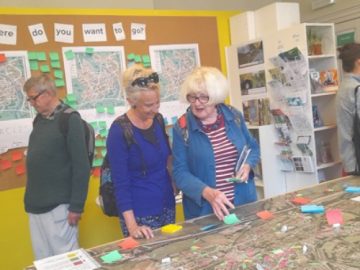 Over 500 different issues were logged on the Big Town Map (pictured).
The season concluded with a Citizen’s Assembly where a number of ‘asks’ of local councils and others were agreed. These included wider pavements; better enforcement of and a wider area for the 20mph speed limit; reductions on traffic travelling straight through the town; greater priority at road junctions for pedestrians and other non-car users (especially at Lansdown Place and the Eastgate-Phoenix Causeway-Waitrose junctions); the introduction of ‘school streets’ in six locations; improved cycle paths and the creation of a proper cycle network; and improved links to surrounding settlements.
 So what happened next?
The groups that had worked together to co-ordinate the transport season met at Human Nature’s offices on North Street in August. After reviewing the 500 issues and the asks as listed above, those in attendance agreed that a “Movement Strategy for Lewes” was needed to address people’s wishes and challenges for getting around Lewes.
A movement strategy is a plan that considers the needs of all transport users – including pedestrians, cyclists and other ‘wheelers’, bus and rail users and other vehicle users – be they resident or visitor.
The Town Council agreed to ‘take the lead’ on this project and established a Project Board comprising Lewes District Council, Lewes Climate Hub, Human Nature (as a key developer within Central Lewes), a business representative, Cycle Lewes, Lewes Living Streets and local transportation expert Shane Snow. The Project Board met with East Sussex County Council’s Local Transport Plan team in December who have agreed to co-operate with the work and to comment on it at key stages.
The Project Board agreed a ‘vision’ to ‘develop people-centred mobility services available to all’. The aim is to develop a set of design principles over the next few months for discussion with key stakeholders – community groups, bus operators, traders, and crucially the County Council who have responsibility for highways – before more detailed plans are worked up later in the year for wider discussion.
To help with the technical analysis associated with this work the Project Board have retained (using funds secured by Cycle Lewes from Ouse Valley Climate Action) the services of a transport consultancy with an excellent reputation for the development of people-centred mobility services, Phil Jones Associates, who started work in December.
Out and about
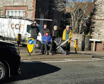
On a cold day in January, the Phil Jones Associates team and members of the Project Board spent over six hours walking around the town reviewing most of the locations and issues raised in the Big Town Map at the Lewes Climate Hub transport season.
We looked at (and sometimes even measured) pavement widths; junction crossings; traffic speeds and enforcement at Cliffe High Street for instance; potential school streets at Potters Lane and Mountfield Road, pedestrian and cycle links to neighbouring settlements (including Cabbage Walk, the Egrets Way and the cycle link to the A27); as well as the issues associated with more ambitious proposals for partial pedestrianisation of more parts of the town. We looked to assess the needs of buggy and wheelchair users by having these with us (pictured).
The Phil Jones team are accessing traffic data using mobile phone, satnav and similar technology, to help them build up a better picture of traffic volumes, key routes and pinch points around Lewes in order to help identify opportunities and challenges as well as possible mitigations.
Next steps
The Project Board hopes to be able to approve some initial design principles and commence discussions with key stakeholders later this Spring. The outcome of these discussions will determine the nature and timings of the next stage of work.
Look out for further updates in the Lewes Climate Hub monthly newsletter.